File:Comparison satellite navigation orbits.svg
From testwiki
Jump to navigation
Jump to search

Size of this PNG preview of this SVG file: 512 × 512 pixels. Other resolutions: 240 × 240 pixels | 480 × 480 pixels | 768 × 768 pixels | 1,024 × 1,024 pixels | 2,048 × 2,048 pixels.
Original file (SVG file, nominally 512 × 512 pixels, file size: 42 KB)
This file is from Wikimedia Commons and may be used by other projects. The description on its file description page there is shown below.

|
This image is an animated SVG file. The .png preview above created by RSVG for use in Wikimedia is not animated and may be incomplete or incorrect. To see the animation, open media:Comparison satellite navigation orbits.svg. It should run in any modern browser or viewer. Recent versions of Chrome, Firefox, Microsoft Edge, Safari, and Opera all support SVG animated with SMIL.
Other SVG animations can be found at Category:Animated SVG files.
|
Summary
| DescriptionComparison satellite navigation orbits.svg |
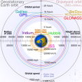
English: Comparison of GPS, GLONASS, Galileo and COMPASS (medium Earth orbit satellites) orbits with International Space Station, Hubble Space Telescope, geostationary and graveyard orbits, and the nominal size of the Earth.
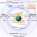
Français : Comparaison des orbites GPS, GLONASS, Galileo, Iridium et Beidou avec celles de la Station spatiale internationale et Hubble ainsi que l'orbite géostationnaire, l'orbite de rebut et la taille de la Terre.
|
| Source | Own work |
| Author | cmglee |
| Other versions |
[edit] English: Animated Español: Animada Македонски: Анимирано Русский: Мультипликация Українська: Анімація
English: Static Македонски: Обична слика Русский: Обычная картинка Українська: Статичне зображення
|
| SVG development InfoField | This diagram is translated using SVG switch elements: all translations are stored in the same file. |
Assessment
| This file was selected as the media of the day for 12 August 2020. It was captioned as follows:
English: A detailed and informative diagram that brings to life where different satellites (e.g. the International Space Station vs. the GPS satellites) are physically located relative to Earth
Other languages
Čeština: Detailní diagram ukazující, kde se na oběžné dráze kolem Země fyzicky nacházejí různé uměle vyrobené satelity, např. Mezinárodní vesmírná stanice nebo součásti sysému GPS. English: A detailed and informative diagram that brings to life where different satellites (e.g. the International Space Station vs. the GPS satellites) are physically located relative to Earth Français : Diagramme animé présentant les principales orbites des satellites artificiels autour de la Terre.
|

|
This is a featured media on Wikimedia Commons and is considered one of the finest files.
If you have a file of similar quality that can be published under a suitable copyright license, be sure to upload it, tag it, and nominate it.
|
|
Licensing
I, the copyright holder of this work, hereby publish it under the following licenses:
This file is licensed under the Creative Commons Attribution-Share Alike 3.0 Unported license.
- You are free:
- to share – to copy, distribute and transmit the work
- to remix – to adapt the work
- Under the following conditions:
- attribution – You must give appropriate credit, provide a link to the license, and indicate if changes were made. You may do so in any reasonable manner, but not in any way that suggests the licensor endorses you or your use.
- share alike – If you remix, transform, or build upon the material, you must distribute your contributions under the same or compatible license as the original.

|
Permission is granted to copy, distribute and/or modify this document under the terms of the GNU Free Documentation License, Version 1.2 or any later version published by the Free Software Foundation; with no Invariant Sections, no Front-Cover Texts, and no Back-Cover Texts. A copy of the license is included in the section entitled GNU Free Documentation License.http://www.gnu.org/copyleft/fdl.htmlGFDLGNU Free Documentation Licensetruetrue |
You may select the license of your choice.
| Annotations InfoField | This image is annotated: View the annotations at Commons |
Captions
Earth satellite orbits
Сравнительные характеристики орбит искусственных спутников Земли
Satelit mengelilingi (orbit) bumi
地球卫星轨道
مدارات الأقمار الصناعية حول الأرض
image/svg+xml
2cf5d382b563a0eac7ecd7322d221f0fb0d6bbbb
43,502 byte
512 pixel
512 pixel
File history
Click on a date/time to view the file as it appeared at that time.
| Date/Time | Thumbnail | Dimensions | User | Comment | |
|---|---|---|---|---|---|
| current | 05:48, 27 February 2021 |  | 512 × 512 (42 KB) | wikimediacommons>Glrx | Fix SVG errors: systemLanguage attr on desc element; misuse of switch element; use SVG 2.0 rules; delete DOCTYPE |
File usage
The following page uses this file:


